
With just a week left until the fall semester kicks off, we continue our introduction of new professors in MSEM. Last week we featured Professor Simon Scarpetta, who brings expertise in paleontology and ecology (here). This week, we welcome Professor Paul Nesbit.

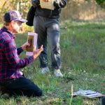
Paul Nesbit is our newest GIS professor whose interest in our changing Earth started early on. The integration of new geospatial technologies to solve environmental challenges is what really captured his interest and he looks forward to bringing his passion and learnings into the classroom. His research background is at the intersection of modern digital geospatial technologies and geologic mapping, aimed at the assessment, documentation, and application of complete geospatial workflows to analyze and better understand fundamental geologic and geomorphological challenges. His current research implements drone-based photogrammetry, remote sensing, deep learning image analysis, and 3D geovisualization for education and science communication using video game engines and web-based methods.
One aspect of USF Prof. Nesbit is most looking forward to is collaboration across USF and the Geospatial Analysis Lab (GsAL). With evolving technology, the GsAL will be a place for him to teach a variety of geospatial programs and for his students to analyze important aspects of our dynamic environment and how to apply their insights and data to management practices. In his classroom, students can expect an engaging and hands-on content approach with clear guidance on how to successfully achieve course and individual learning goals. Prof. Nesbit enjoys teaching and hopes his students will share his enthusiasm for these evolving geospatial technologies and methodologies.
You can read a variety of Paul Nesbit’s publications here.